Ptit Train du Nord: Official app for 234 km trail
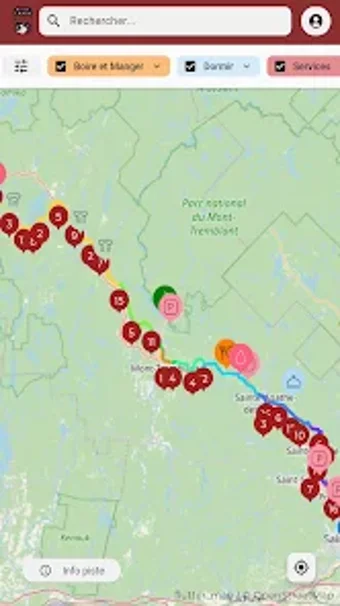
Ptit Train du Nord, from Usine Galaxie, is the official digital companion for the 234 km Laurentian linear park, designed to help cyclists, hikers, and skiers navigate the corridor. The app maps the entire trail and displays real-time GPS position while offering an offline-ready interactive map, service directories, and Info-piste condition updates to plan outings. It also lists Certified Café de Gare partners and local repair shops. Outdoor enthusiasts and regional tourists gain consolidated route data and local service points for multi-day or day trips.
The app centralizes official trail data and navigation tools
Official route and service listings appear on an interactive map that covers the full linear park and replaces older mapping tools. The app links live positioning to a directory of water points, restrooms, parking and station cafés and partners. Offline-ready maps allow map tiles and service listings to be used in remote sections, and planning tools help arrange multi-day legs or short excursions before setting out.
GPS position and offline maps hold up in remote trail sections
Real-time GPS tracking shows your device position on the interactive map and the app is designed to work where cellular reception is intermittent. Info-piste updates provide trail-condition notices and seasonal changes. Because mapping and essential directories function offline, the app keeps location reference and service visibility even when the device cannot reach an online connection, though live external data such as partner availability requires network access.
Designed for corridor exploration, with clear scope and platform reach
The app targets cyclists, hikers, runners and winter-sport users and includes planning tools for multi-day expeditions and short outings, matching the park's visitor services. It is published by the park organization through the developer and is available on mobile stores for common devices. A practical limitation is the app's specialised focus on the linear corridor, so it does not serve as a general regional map outside the trail network.
Strong fit for trail visitors who need official, corridor-focused guidance
The app is a pragmatic choice for cyclists, hikers and winter-sport visitors who want an official mobile companion tailored to the park's corridor, backed by the park organization. It best serves people planning multi-day or day trips along the route; users should verify partner availability and download necessary map data before entering remote sections, and ensure their use aligns with local rules and platform terms.